
Key takeaways
- Google launched and immediately withdrew an AI image generation feature from Google Earth after one day due to misuse concerns.
- Critics highlighted how embedding an image generator into a trusted mapping tool creates risks for spreading fabricated geospatial evidence.
- The incident reflects broader challenges in deploying AI image tools at scale without safeguards against misinformation.
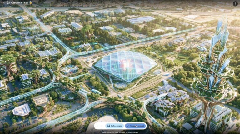
Google on Thursday introduced a new capability to its Google Earth application that would let users deploy its AI image generator to fabricate visual content directly atop the platform’s satellite imagery. Powered by what Google called Nano Banana 2, the feature accepted text prompts and superimposed generated images onto real geographic coordinates, allowing users to reimagine landscapes or test hypothetical scenarios.
Google’s Swift Reversal
Within hours of going live, the feature faced intense criticism. Critics flagged an obvious vulnerability: the tool operated with minimal safeguards against misuse, creating an ideal environment for synthetic imagery to be broadcast as documentary evidence of real locations. A journalist from the BBC posted a particularly pointed response on Thursday, noting sarcastically that embedding an unrestricted image generator into one of the web’s most trusted sources of visual reference material—used daily by newsrooms and researchers—seemed designed to spread misinformation.
The One-Day Withdrawal
Within a day of launch, Google reversed course entirely. In a statement, the company acknowledged the tension: “We’ve seen geospatial professionals using this feature for a range of useful purposes, however we’ve also seen people sharing screenshots of generated imagery that appear to violate our policies.” Google continued: “We’re rolling back this feature in Google Earth while we work on implementing stronger guardrails.”
The removal was unusually fast for a consumer-facing AI feature. The speed reflected the immediate visibility of the tool’s risks and how quickly critics mobilized public attention. Screenshots of generated imagery had already begun circulating on social media, with some apparently violating Google’s usage policies. Google’s apparent calculation was that the reputational cost of defending the feature outweighed any benefit from keeping it live.
The Misinformation and Geospatial Trust Problem
How Fabricated Imagery Could Be Weaponized
Placing an AI image generator directly into a mapping and satellite imagery application creates a high-efficiency channel for manufacturing and distributing synthetic content in a context where it’s likely to be believed. A user could generate a realistic image of infrastructure—a new bridge, a military installation, an environmental disaster—and place it on a real map location. Screenshot the result. Distribute it on social media or to journalists or researchers. The image carries the implicit authentication of Google Earth’s satellite data, even though the specific content is entirely fabricated.
The concern was not hypothetical. Geospatial data occupies a unique position in the information ecosystem. Satellite imagery, maps, and location-based visual content are regularly cited in journalism, peer-reviewed research, legal proceedings, policy debates, and intelligence analysis precisely because they’re perceived as objective, verifiable records. They’re used to document human rights abuses, verify military movements, track environmental damage, and settle territorial disputes. An AI system capable of seamlessly altering that visual record—making fabricated content indistinguishable from authentic satellite data—fundamentally undermines institutional trust in those sources.
Google did acknowledge that some users employed the tool constructively. Geospatial professionals, urban planners, and researchers used it for legitimate creative and analytical purposes. But the scale of potential misuse for disinformation rapidly outweighed the narrower benefits.

The Broader Landscape of AI-Generated Visual Content
Google’s Nano Banana 2 feature is part of a much larger shift in how visual information is created and distributed. By 2026, AI image generation tools have matured to the point where creating convincing synthetic visual content requires no specialized skills, no software expertise, and no artistic training. A text prompt submitted to any number of commercial AI services accomplishes what once required professional-grade software and hours of work.
Google itself sells image generation capabilities to enterprise and consumer customers. Competitors—including other major tech firms, specialized AI startups, and open-source projects—offer equivalent or superior tools. The broader web is already saturated with AI-generated imagery. Distinguishing synthetic photos from authentic ones is becoming increasingly difficult for both humans and automated detection systems.
The risk of AI-generated imagery being used for misinformation isn’t new. What made Google’s approach distinctive was the combination: the company built image generation directly into a tool explicitly designed to display real geographic data, creating a streamlined pathway for synthetic images to be confused with, or deliberately presented as, authentic satellite reconnaissance.
What Comes Next: Guardrails and Uncertainty
Possible Safeguards
Google committed to reintroducing the feature only after implementing “stronger guardrails.” The company has not yet specified what those safeguards will be. Plausible approaches might include requiring users to label generated imagery as synthetic before sharing; restricting where on the map users can place generated content; requiring authentication or verification to use the feature; or limiting access to registered professionals in specific domains.
But each approach presents trade-offs. Guardrails that genuinely prevent misuse may simultaneously eliminate legitimate use cases, making the feature too restrictive to justify maintaining. Conversely, safeguards designed to preserve creative utility may be circumvented by users determined to spread false information.
Google’s statement emphasized that geospatial professionals found genuine value in the tool, suggesting the company intends to preserve it in some form. The period of withdrawal appears designed to buy time—allowing the company to determine whether a safe version is technically or operationally feasible, and whether demand justifies the engineering effort required to defend it against misuse.
The broader question remains open: can an AI image generator be embedded into a mapping application without creating systemic risks to the integrity of geospatial information? Or are those risks inherent to the combination, regardless of what guardrails are applied?
Frequently Asked Questions
What feature did Google launch and withdraw?
Google rolled out a feature in Google Earth powered by Nano Banana 2 that allowed users to generate AI images and superimpose them over real satellite imagery on maps.
Why did Google pull the feature so quickly?
Google said it rolled back the feature because users were sharing screenshots of generated imagery that appeared to violate company policies, and the tool could be misused to spread geospatial misinformation.
Will Google bring the feature back?
Google stated it is rolling back the feature "while we work on implementing stronger guardrails," indicating plans to reintroduce it once safeguards are in place.
